By
Image source: AdobeStock
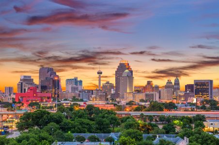
When Dr. Esteban Ochoa moved to San Antonio several years ago, he couldn’t believe the oppressive heat that instantly greeted him. But his own discomfort took a back seat when he surveyed San Antonio’s historic West Side neighborhood, a predominantly Hispanic, lower-income area filled with a mix of commercial buildings and residential housing, which offered little relief from the searing sun.
Ochoa found that a majority of its generational residents lived in structurally compromised homes that lacked basic cooling efficiencies—sealed windows, no central air, and minimal ventilation. In some cases, indoor temperatures in these disadvantaged tracts reached up to 125 degrees, turning living rooms into overnight ovens and making living conditions potentially lethal.
To better understand and address these urban heat islands, Ochoa, an associate professor of urban and regional planning at the University of Texas San Antonio, turned to AI-driven tools. With funding from the city’s department of resilience and sustainability, he and his team began using computer vision models trained on street-level imagery to identify signs of housing disrepair and predict which homes were at risk of demolition. After determining physical deterioration patterns, researchers placed sensors inside and around homes to capture real-time temperature data, providing insights that feed into more advanced AI and simulation efforts—like microclimate modeling and “digital twin” technology.
By combining on-the-ground data with large-scale simulations, the team has started to understand how heat interacts with building materials, urban layout, and socioeconomic factors. The urgency behind this work accelerated after San Antonio’s brutal summer of 2023, when the city endured 75 days above 100 degrees. That stretch became a wake-up call for city leaders. “There was something that we needed to do about this,” says Leslie Antunez, an administrator in San Antonio’s Office of Sustainability. “We were essentially writing the playbook for San Antonio. What works for us? How do we make it work? And what do we do with what we have?”
Rather than starting from scratch, city officials evaluated heat-mitigation work already underway across departments. They found that several efforts, including cool roof installations and large-scale tree planting programs, were already reducing heat exposure without being explicitly categorized as climate resilience initiatives. Since launching its cool roof program, the city has installed roughly 2,000 reflective roofs, backed by about $1 million in annual operational funding. Tree planting efforts, supported in part by an environmental utility fee, have also expanded in neighborhoods identified as high-need.
What the city needed, however, was better evidence for newer interventions, particularly cool pavement. That’s where Ochoa’s research became critical. Antunez says the city wanted to ensure taxpayer dollars were being invested in solutions that actually worked. “As a project manager, you want to make sure that you’re being fiscally responsible,” she says, “and investing taxpayer dollars in things that are going to give us that benefit.”
Ochoa’s data has helped validate San Antonio’s heat mitigation strategies and guide implementation. His research on cool pavement performance over two years produced findings consistent with cities like Phoenix and Los Angeles, both national leaders in urban heat adaptation. Those insights have influenced infrastructure planning, helping San Antonio decide where cooling interventions like pavement treatments, shade infrastructure, and tree canopy expansion will have the greatest impact. “The city is really invested in cooling down neighborhoods and doing as much as possible,” Ochoa says. “But they are also making sure that their investments are as efficient as possible and delivering the results they’re supposed to.”
Across the country, cities are facing more complex challenges than ever—from extreme heat to aging infrastructure—and turning to artificial intelligence for answers. In Brunswick, Georgia, officials are using AI to predict street-level flooding with high-frequency sensor networks. Atlanta is one of several cities partnering with the Smart Surfaces Coalition to implement cold roof ordinances. Meanwhile, in Pittsburgh, Carnegie Mellon University researchers are using predictive analytics to anticipate infrastructure needs, improving efficiency and reducing long-term costs.

Image Source: AdobeStock
At a time of extreme weather and climate change, these AI tools and models offer municipal leaders practical insights into how data-driven decision-making can create more resilient, responsive, and livable communities. “We know these AI models are powerful, but they’re only as good as the information they have available,” says Dean Burkmeister, Deputy Director of Data & Tools at the Smart Surfaces Coalition. “The more data points you can collect, especially local ones, to fill in those data gaps, the more useful their insights are going to be.”
Long before “smart cities” became a buzzword, engineers at NASA built early versions of what we now call “digital twins”—virtual replicas of spacecraft used to test how systems would behave under the unforgiving conditions of space during the Apollo missions. Decades later, that same concept has found new life on Earth, as cities begin constructing detailed digital stand-ins of their own streets, buildings, and infrastructure.
By mirroring the physical world in data, these digital twins allow planners and researchers to simulate everything from heat waves to flooding scenarios, testing how different interventions might play out before committing real-world resources.
In Brunswick, the technology has been vital for a city that both Amol Sagar and Naomi Latini Wolfe say, “represents a critical nexus where a delicate coastal ecosystem meets heavy industrial trade.” The port city faces the dual pressures of rising sea levels and the potential of a renewed industrial boom. Thanks to LiDAR-based elevation maps and real-time data from a 15-site sensor network, the public works department can forecast (and experiment with) street-level flooding—and therefore can deploy mobile pumping and close specific roads well before encroaching coastal waves reach the shore.
Since 2024, the research team at UTSA has taken a granular approach to its digital twin work in San Antonio. Led by researcher Farzad Shahedi and backed by the National Science Foundation, the team built a digital twin of 10 homes on the city’s West Side. Each one is outfitted with sensors to capture the temperature data from uninsulated rooms—as well as climate data around the housing units. The goal is for the model to mirror reality as closely as possible, so researchers can map heat across entire communities and identify the pockets most in need of intervention.
With these digital copies, Shahedi’s team can then run all kinds of experiments and “what if” scenarios regarding roof types and building materials to determine how changes affect temperatures and energy pricing. What happens if a cluster of homes switches to reflective roofing? If more trees are added? If average temperatures climb another degree or two? (According to the SA Climate Ready plan, by the end of the century, the city will regularly experience up to 100 days a year with temperatures above 100 degrees.)
Per Antunez, the application of their cool pavement program has cooled surface temperatures by 8 to 12 degrees, which equates to about 1 to 3 degrees in air temperature reduction. “For a neighborhood, that’s huge,” Antunez says. “That’s where the digital twin model is huge because then you can multiply that times three, four, five and really augment and see what that could mean or look like for a whole subdivision—or a whole 10-block radius.” The model weighs these changes against costs and trade-offs, and, over time, becomes more accurate as more simulations get fed into the system.
What sets some of this work apart is emphasizing accuracy over speed. Both Ochoa and Shahedi note that they’ve invested in more methodical, physics-based simulations with a proprietary EMVI-met software that models how heat moves through the air and on surfaces throughout the day. “This is a much better approach than just running and putting in temperature data from the airport station and then maybe a couple of buildings here and there and trying to let machine learning figure it out,” Ochoa says. “We’d like to be a little bit more accurate and responsible with the outcomes of this—and how these outcomes are really informing weather and physics.”
The research and resulting data have become essential to implementation, giving city leaders a clearer framework for deciding where and how to invest in heat mitigation. After two years of studying cool pavement, San Antonio has shared its findings with public works officials, who are now determining how best to integrate those materials into long-term street preservation plans. But the city’s broader goal extends beyond evaluating single interventions in isolation. By layering cool pavement, tree canopy expansion, shade infrastructure, and housing improvements into one neighborhood-scale model, officials can better measure cumulative impact and adjust strategies in real time.
“We want to make sure that we can confidently say that X amount of investment or X amount of infrastructure changes will give us this reduction,” Antunez says. That iterative process, she adds, allows the city to actively monitor results, refine interventions, and ensure public dollars are producing measurable benefits for residents most vulnerable to extreme heat.
Image source: AdobeStock
One of the bigger challenges the SSC faces is relaying how smart infrastructure can solve inefficiencies across various branches of city government. As Burkmeister notes, municipalities often contain various silos between departments, which means, for example, that public health officials are rarely in communication with park officials about the co-benefits of tree planting and green space. It ends up hurting the city financially.
“The city as an organism is expending all of this money on day-to-day operations that are actually worsening the problems,” Burkmeister says. “From just an economics perspective, we found that it’s much more cost-effective to design cities in a way that addresses these multifaceted challenges than it is to think of all the solutions and problems piecemeal.”
Over the last three years in San Antonio, Antunez’s team has been correcting those problems, working across departments with the same project managers (a benefit of the city’s small turnover rate) to share the co–benefits of their initiatives and research. “We have been consistent, we have regular check-ins, and have set up these mechanisms to make sure that we don’t lose the momentum,” Antunez says. “It’s people who have been working in this space who want to help, who are doing some initiative in one way, shape, or form that supports the work that we’re doing.”
The same approach is crucial for residents, too. Because the use of AI in these projects can bring up ethical concerns, specifically over how data is being captured, Ochoa and his research team have made it a priority to engage and inform the community about their work. So far, transparency—and the ability to communicate in a preferred language—has been vital in developing trust and attaining the information they need to encourage policy changes.
“I speak Spanish most of the time when I’m in the field installing these sensors and engaging with people,” Ochoa says. “This cultural and technical diversity is super needed when deploying these types of efforts.”
Ultimately, this kind of work and collaboration requires a holistic perspective from city leaders, and a proactive approach that makes real environmental and economic sense—before it’s too late. “It will save taxpayers money. It will improve public health. It will improve quality of life. It will reduce extreme heat risk. It will reduce flooding risk. And it will improve air quality for millions and millions of people,” Burkmeister says. “We think it’s a win-win.”